Friday, December 26, 2008

Cambria to Los Angeles And Heading For Home

After a good nights sleep I woke up about 9am and started to sort out all the things I have loose in the car to enable me to get them all into luggage for the trip home. I have already taped up my last parcel for postage home so I need to arrange everything left to fit into my suitcase, my carry on bag and my laptop case.

I loaded up the car and found a post office to post off the last parcel home. A quick look through an Antique shop turned up nothing to add to my collections and I then found a dinner and had an early lunch and turned the car onto highway 1 for the run down to Los Angeles.

It was another hot day for driving but being on the coast helped keep the temperature down to about 90 degrees. Following the cost provided plenty of photo opportunities and some nice places to pull over for a break. I stopped at Avila Beach which looks like a good weekender type place for people coming up from LA. It was quite during the weekday I was there but it is a real beach side holiday spot.

Back on the road I was passing plenty of farmland growing crops and then started to come into the larger city's like, Santa Maria, Santa Barbara. There were once again a lot of wind farms for electricity as well.

I came into Los Angeles onto a 6 lane each way highway. I pulled off the freeway to fill up the car with petrol and I drove it through a $5 car wash to clean it up. Whilst paying for the petrol I found two coke cans that were different and I put them into my luggage full as I had nowhere to keep them if I emptied them.

My navigation system directed me straight to the Hertz depot at the airport. You leave the car and get onto a shuttle bus provided by Hertz that takes you directly to the terminal you need to get to.

Going through the security check I was stopped and made to open my carry on case. They had noticed two large cylinders with something in them that they could not distinguish. It was my two Pringles cans full of casino chips I was carrying home. Once I explained what they were I was okay to proceed through to the boarding area.

I arrived three hours before the flight so I had plenty of time to relax and read.

The trip home was quite good. The plane was only half full and I managed to have three seats to myself so I was able to lie down and sleep across the seats. The steward on the flight noticed my Beer Can Collecting polo shirt and passed comment on it. I explained to him what I had been doing on my holiday and asked him if they had any of the special James Squires beer cans on the flight. He said they did and told me to come up to the galley after the dinner had been served. I was able to get two sets of the three cans from him plus I mentioned I also collected Qantas memorabilia and later during the flight he bought me two bags of all the different give aways on the flight. It was a good haul for my collection.

The plane arrived back in Sydney on time and customs was quick coming through so I was out of the airport in about 45 minutes. I had to wait about 20 minutes for the shuttle bus before heading home.

It was a great trip. Meeting family and friends in Singapore and England, a great time in Dublin at the Guinness Brewery and watching the Gaelic Football and Hurling. The USA section was brilliant, Firstly the Canvention, what an eyeopener. I made a lot of new friends, got some good items for my collection and generally had a ball. Vegas was fantastic, it is a place I will want to go back to. Then driving through Death Valley, Yosemite, San Fransisco and down the coast to LA. Really it is to hard to pick a favorite of all of the things I did.

Everything went to plan. My Internet bookings all worked out, people were so friendly, the collecting was superb.

Cant wait for next years trip, as I am planning on going to the Canvention in the USA again. It is in Springfield Illinois.

Tuesday, October 14, 2008

Golden Gate Bridge - Highway One (Three Yellow Lines) 8th September

I only post this now due to the fact I was looking for the photos of the last two days of the trip for a while and I could not find them, then i forgot about this blog with everything else that is happens. They still haven't turned up and so I have to post them without the photos. Here it is.
----------------------------------

Before I left on my trip and I knew I was going to be in California with time to do some driving, I knew I had to see the Golden Gate Bridge. By seeing it so often on TV and in pictures it has really appealed to me. It is like how I really like viewing the Sydney Harbour Bridge and marvel at how it was built before all the modern equipment was available. They both are from a different era. Nobody would even attempt too build a bridge like either of these today.

Got up this morning and packed the car before going to put some petrol in the car. My motel was right near the freeway entry so filling with gas and getting onto the freeway only took fifteen minutes and I was on my way.


I had about two hours driving to get to San Francisco and I pulled off the freeway once to get some breakfast and then arrived on the eastern side of SF just about ten o'clock. Following the GPS it lead me over the Oakland Bridge into the centre of San Francisco and along some of the main city streets towards Fisherman's Wharf before turning left following the harbour front until I looped onto the approach to the Golden Gate Bridge. I filmed crossing the bridge and as soon as you get to the northern side you turn right into a viewing area.


I took some video and a lot of pictures, unfortunately it was overcast and quite windy whilst I was there. Walking around the viewing area there are some memorials to the various mariner groups At the centre of this is a bronze casting of "The Lone Sailor" who represents all sailors who have sailed out under the bridge in service of their country. Around the sailor are tributes to the Navy, Marine Corps, Merchant Marine and Coast Guard.


Whilst looking at these and taking some photo's I heard my name being called out and turned around to see two blokes waving at me from the upper deck of a double decker day tour coach. It was Doug & Keith, two of our Aussie group who went to the Canvention in Orlando. I spoke with them for five minutes before the bus departed to it's next stop. They had been to Vegas also and then spent four days in San Francisco looking at all the sights. They were flying home to Sydney tonight. It was a welcome surprise to see two people from home when I would not of expected to see anyone.


I was surprised at the viewing area that there was no information building or shop. I had wanted to get some books on the history of the bridge so it was disappointing that there was nothing there to be bought.


I jumped back into the car and turned back under the freeway to go back south across the bridge and there was a sign saying Golden Gate Recreational Area, so I head off on that road instead of going back over the bridge. There is a few areas to pull off the road to get photos of the bridge and if you follow the road around you get to Rodeo Beach where there is a large marine research centre. Driving back around toward the bridge I came across the Golden Gate National Park Visitors Centre which was open so I stopped and went in. They had a good selection of Golden Gate Bridge items to buy and I purchased a t-shirt and two books on the history of the Golden Gate Bridge. Outside the Visitors Centre there were some deer wandering along the roadside.


I then drove further around the headland and came across a US Army base. It is actually a old base that was one of the Nike Missile Sites that were set up to have anti-aircraft missiles deployed in case of enemy attack on the USA. I then drove back towards the Bridge and stopped and got a few extra photos from another angle before driving over the bridge and going to the pylon base of the southern end of the bridge.


This area is known as Fort Point due to the fact that the southern bridge pylon has been built right next to a Fort what was built in 1850's. The fort was built to protect San Francisco's bays and as a major protection for San Francisco from naval attack. The fort itself is built of brick and the structure is described as one of the most perfect examples of brick masonry in the USA.


I walked into the fort and looked around plus checked out the bridge from below. The cold day even felt cooler here as it is quite windy at the side of the bay. Several tourist boats were in travelling around the harbour and there was even an antique Fire Engine doing tours of the city.


From here I left to follow the coast road south. Straight away I drove along Lincoln Boulevard and onto El Camino Del Mar which was an old trail way between Spanish missionary outposts in the 17th and 18th centuries. You see a lot of mentions of this road all the way along your drive along Highway 101 all the way to Los Angeles.


Whilst driving along this road you pass through the Lincoln Park Golf Course which includes some holes with great views of the Pacific Ocean and the Golden Gate Bridge. From there I drove across to the western coastline to a beach area and past the San Francisco Zoo. It was now about 2pm and I still had over 200 miles of driving to do for the day to get to my accommodation plus I still had a list of micro breweries to visit in Santa Cruz. So my original plan to totally follow the coast road needed some revising as there would be not enough time to stop at the breweries if I did that.


I headed slightly inland and started looking for somewhere to get some lunch. I ended up in Belmont and grabbed some lunch in a shopping mall. From there I picked up highway 101 and headed south towards Santa Cruz following the directions on the GPS navigator.


By the time I got to Santa Cruz it was about 3.30 and I headed straight to the Seabright Brewery which is celebrating it's 20 year anniversary as a brewery. They have a great building which is really spacious and a great outdoor area as well. I stopped long enough to speak to the main brewer Jason Chavez about their setup and the different brews and got some information from him on the other micro breweries in the area. Before leaving he gave me a heap of coasters and a shot glass with their name on it and I bought a couple of T-shirts.

I was out of money so I had to find an ATM to get some money before heading off to the next stop. I had to go across town to the Santa Cruz Mountain Brewing Company. They have a small bar on site for you to quench your thirst whilst picking up some takeaways. I spoke with the lady behind the bar and she checked for t-shirts, coasters and labels in the storeroom but there was none to be found. I spoke with her for a few minutes and was about to leave when she called out to me to wait and then came over and gave me a pint glass. She said she found it next to the bar and sorry it has a crack in it but I could have it. Luckily the crack was in the back of the glass so it is a good addition to my collection.

By now it was 5.30pm and I headed off to the Santa Cruz Brewing which was on the outskirts of the city. By the time I got there unfortunately it was closed for the day so I missed out on meeting the people.

It was then time to get the GPS working to find my way south towards Cambria. I drove for about an hour passing Carmel and arrived at Monterey where I pulled off the freeway to get some petrol and also call my motel for the night to tell them i would be there late. They said the reception closed at 10.00pm and if I was not there by then that they would leave the door key under my entry mat at the room. I told them where I was and the man said I had about three and a half hours drive to get there. As it was starting to get dark I decided to get some dinner and called into a supermarket where I found some M&M containers I did not have. I also got some food and ate it before taking off again. Once on the road I started down the the coast road.

The main freeways between San Fransisco and Los Angeles travel inland from the coast but there is a California State Highway 1 which in this section follows the coastline. It is a single lane each direction. At night whilst I was travelling it all you could see was yellow lines to follow. two in the centre of the road and one on the right side of the road.

For the next three hours these three lines became my good friends. It was a cloudy night and the road has no lighting so unless there are other cars all you can see is the three yellow lines.

Occasionally you would see the lights of a ship travelling off the coastline and I think I went through two small townships as well. The road many times doubled back on itself quite sharply and you would only be travelling about 20 kph. There were so many turns and up and down hills that I actually felt seasick and had to stop to get out of the car to get some fresh air at one stage.

Finally I came to the township of Cambria and found the motel about 10.30pm and finding the key under the mat as promised I quickly got all my stuff out of the car and after a very long day of driving I was asleep very soon after settling into the room.

Saturday, September 20, 2008

Yosemite National Park - 7th September

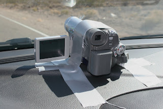
Up early again and packed the car, got petrol and left Lee Vining by 7.30am this morning. I am travelling today into Yosemite National Park. Firstly I need to drive along state highway 120 over the Tioga Pass which travels west from Lee Vinning over the Sierra Mountains reaching a height of 9,943 feet (3,031 metres) at its highest point. I decided to video my trip up the mountain range so I again taped the video camera to the dashboard.

In winter this road is closed due to snow. It is normally open from early June till the beginning of November (approx. 150 days) but if it is a long snow season this road may only be open for as little as 100 days.

On the way up the pass I entered the Yosemite National Park but was too early in the day for the people collecting the park entry fee. There was a sign saying I will need to pay it when I leave the park at the other end later in the day.

My first stop was at a parking area which provides a viewing spot for Lembert Dome.

There was a sign saying have a coffee with a park ranger from 8.00am. Well it was 8.00am and not a park ranger to be seen anywhere. You can climb to the top of the dome by walking on the trail that goes around to the other side of the dome and then climb up the far side. It is a total of 2.8 miles but they say to get there and back will take you half a day with all the climbing to the top of it. The top of the dome is 900 feet above where I took the photo from.

Next I drove along to the Visitors Centre located at Tuolumne Meadows which is only 5 minutes away by car. I got out of the car to look inside the Visitors Centre but it does not open till 9.00am so I jumped back into the car and continued on further across the mountains. I stopped a few times at turn offs (which are just places to stop to view the scenery) and took some photos of the cliffs and valleys.


My next stop was at Tenaya Lake. The lake is a mile long and you can do a 2 and a half mile walk around it if you have the time. The lake is surrounded on three sides by granite rock cliffs.

From there, it is only a few minutes drive to Olmsted Point. From the car park you can view Half Dome one of the main features geological of Yosemite.


But if you walk the 150 yards to the top of the point you can see all the way down the valley to Half Dome and to the left of the valley at a peak called Clouds Rest. You walk up one hundred feet in elevation for the 150 yards to get to the point. At this elevation (8,300 feet) it is a hard enough walk to make your heart really pound by the time you have walked the distance.

There are also large granite boulders sitting on top of the point which would have been placed there when the area was a glacier during the last Ice Age.
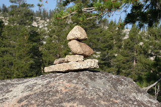
People who walk the trails here quite often pick up small rocks and stack them up on top of each other to form pillars. There are thousands of these all through the park.


At the top of the point it is a slightly rounded granite peak with only one tree growing out of it.
From there it is a slow drive through a pine forest to Crane Flat where there is a road junction that leads into Yosemite Valley. The other direction leads west to San Francisco and Los Angeles.
At this point you could walk a trail to the Tuolumne Grove, which is a grove of giant Sequoias trees. These trees are the tallest in the world reaching up 380 feet (115 metres) and can be up to 26 ft in diameter. In this grove is the old road into the valley, which was for horse drawn coaches and includes one tree that the middle was cut out of for the coach to drive through.


Turning left at the road junction I drove down into the Yosemite Valley floor. You go through a few tunnels whilst gradually winding around the side of the mountains further downwards. You can stop at various places whilst descending to look at the view and take some photos. Once you reach the valley the road crosses the Merced River which flows through Yosemite Valley. The road becomes one way with the road on the other side of the river taking the traffic in the other direction.
In the early 1903 President Theodore Roosevelt came to the area and met John Muir who was a wilderness campaigner. Muir talked to Roosevelt about the importance of keeping areas like Yosemite as federally protected land and not long after Yosemite was declared a National Park.

Once in the valley you have many choices. I decided before leaving home that if it was not booked out on the day I would take a two hour Valley Floor Tour. This tour you are in an open top trailer behind a large pickup truck. There is a Park Ranger sitting in front facing everybody who shows you around the main places in the valley.

I arrived at the village at 11am and checked out the tour booking office. There were spaces available on the 12 noon tour so I bought the $25 ticket. I had to get to the Yosemite Lodge so I was able to get on the free shuttle bus that goes around the whole valley. You can get on and off at any one of the many stops around the valley. Arriving with a bit of time to spare I went to the food hall at the lodge and grabbed a bite to eat.

The tour “bus” as I said is an open top trailer behind a large pickup truck. The trailer is made up of 13 rows of seats that can each hold up to four people.

At the start of the tour the Park Ranger gave us a brief history of the park plus a run down on what we will be doing. From this the tour just moves along through the valley floor.

In no time at all you are checking off the list of highlight spots of Yosemite that you visit. Yosemite Falls, with the longest continuous water drop in Northern America. Not that I saw it as it is seasonal waterfall. It only runs when the snow is melting from early spring until all the snow is gone, therefore going there at the start of fall was not a good time to see the falls.

Next up was ‘El Capitan’ which is a 3000 foot vertical wall of granite. You can not get a sense of how tall this cliff face is until you stop at the side of it about 60 yards from the base and the tour driver points out the climbers on the rock face. You really have to strain your eyes to see a person who is half the size of a pin head on the white granite wall. The driver himself is a rock climber and has climbed this cliff three times. The ranger said it on average takes six days to climb the face of this cliff although people have raced up it in as little as three hours. There have also been quite a few deaths over the years caused by rapid weather changes including unseasonal cold weather and the falling rocks.

The cliff itself is one of the most popular points of Yosemite as it towers over the valley. The park ranger told us that there was a rock slide in the late 1990’s where 1400 tons of rock fell of the cliff face.


From here we travelled along the north side of the river towards the roads what wind out of the valley before turning back across the river and heading back on the road I originally came in on.

Half way back along this road the tour turned right and started moving back up the side of the valley wall and we were taken up to a place called ‘Tunnel View’.

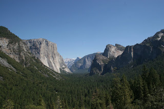
Tunnel View, as the name suggests, is a viewing area next to a road tunnel which enters the park from a south west direction. Here you get a great view of most of the valley’s main cliffs and mountain sides including El Capitan, Half Dome, Bridal Veil Falls as well as the valley floor itself.

The tour stopped here for everyone to get out of the trailer and take some photo’s of what is said to be the most taken photo in the park. Next year is one hundred years since the Yosemite National Park was founded and they are spending a lot of money upgrading the roadways and viewing areas for the special celebration.


Leaving Tunnel View parking area we headed back down into the valley and along the roadway to an area below the Bridal Veil Falls. This is the only falls in the park that runs all summer long. The water flowing over the falls at this time late in the summer season is minimal but during the fast flowing times the water cascades over the falls and spreads out like a Brides veil, hence the name.

It actually looked today with the wind running up the valley that the water is being blown back up over the falls to the creek above.

From here the tour went onto roadways that are not for public thoroughfare and are only access by park vehicles or, push bikes and pedestrians.

We drove towards the eastern end of the valley to an area under Half Dome. Half Dome rises from the eastern end of the Yosemite Valley floor to its peak 4,737 feet (1,444 meters) above. It is a granite dome of which one half has been split away over thousands of years leaving a vertical section facing towards the valley.

People can climb to the top of the dome via a cable route on the reverse side from the valley but it is a full day trek from Yosemite Village.

From there we drove back to where we started the tour past some meadows where the Ranger said that at dusk some deer and bears will often wander around feeding on the grasslands.

Once the tour finished I was able to buy some souvenirs of Yosemite including a couple of books about the park which I am sure I will enjoy reading. I then caught the shuttle bus back to the car park where I had left the car and quickly started the air-conditioning to cool the car down as I had left it in the sun when I left for the tour.

I had a great time seeing the sights of Yosemite via the two hour tour of the valley floor. The scenery is wonderful and if I ever manage to go back to Yosemite I am sure I will stay a couple of days in the park and do some of the walking trails to see even more of the spectacular sights.

It was time for me to head off towards my accommodation for the night. I had booked into a Comfort Inn motel in Manteca, which is in central California east of San Francisco.

Travelling out of Yosemite Valley the same way I entered until I got to the fork in the road at Crane Flat where I had come across the Sierra Mountains from Lee Vinning. Taking the other road I soon came to the western park entrance and paid my $20 fee that I could not pay this morning. From there I drove out of the high country westwards through a lot of very scenic countryside. There are quite a few small country towns where you could stop and walk amongst the old style buildings and soak in the local character. I stopped at a town called Groveland and walked around ending up in the local pub where I was able to pick up some new coasters off the bar.

From there I drove down the new Priest Grade, which is the roadway that takes you off the mountains down a very steep gradient. On the other side of the valley wall is the Old Priest Grade, which is unbelievably about twice as steep as the road I travelled down the mountain on. From there I drove over the dam wall of the New Don Pedro Reservoir which the supplies the valley below with irrigation water for their crops and also has hydro turbines which generate electricity for the area.

From there I travelled on to the town of Oakdale where I went into a supermarket and was able to get a couple of new Pringles cans. From there it was just a 30 minute drive to the motel is Manteca. I arrived in town about 5.30pm and unloaded the car and started making up another parcel to send home. I emptied the Heineken Light cans I got yesterday and also a six pack of 100ml coke cans which I put inside some empty Pringles cans before packing into the parcel.

Then I went out for dinner at The Brickyard Oven Restaurant. I had picked this restaurant over twelve months ago while searching the internet as it is part of the Kelly Brothers Brewing Company Building.
I had seen that there was a micro brewery in town so that is why I picked to stay in Manteca as part of my trip. The building used to be the old El Ray Theatre but in 1977 it had a fire and burnt out. Ironically the picture it was showing at the time was The Towering Inferno.

In 1997 the Kelly Brothers spent 2.5 million dollars fitting out the shell of the old theatre into a brewery and restaurant. They have a “Mug Club”. For $100 annual membership you get a free meal on your birthday, one dollar off every pint of beer you buy in the pub during the year and two tickets on their memorial pub crawl including breakfast and beer all day on the bus between pubs. I know a lot of people who would join the club if they lived anywhere near this place.

After having dinner I sat at the bar watching a baseball game on the T.V. for a while. The barmaid gave me a few coasters (and I pinched a lot more) before going back to the motel where I finished packing the parcel and taped it up. I will find a post office over the next two day before I leave for home.

An early night followed as I have a long day tomorrow with a lot of driving to get to my accommodation and hopefully a good day for a lot of sightseeing.

Monday, September 15, 2008

Lee Vinning & Surrounds - 6th September

I was up at 5.45am this morning. Lee Vinning is situated on the western side of Mono Lake and I had heard that the sunrise over the lake can be spectacular. I was up and ready with both my camera and video camera to capture the sunrise and there was not a cloud in the sky as the dawn light started creeping over the horizon in front of the sunrise.

I took a lot of photos at five minute intervals and 10 seconds of video every couple of minutes for at least 40 minutes as the sun rose. Although it was a clear sunrise I would not think of it a spectacular but I am sure that in the right conditions it would be really something to see.


Because I had spent the last of my trip last night driving in the dark and also due to not having a good look at the northern end of Death Valley due to time restrictions yesterday I decided to retrace my steps back into Death Valley to get a better look at the scenery.

I started off at 7am to ensure that I would be able to travel there before it got very hot later in the day. I was firstly driving down a mountain range that I had driven up last night in the dark and was glad that I had come back as the views were amazing. On my right as I drove south were the Eastern Sierra Ranges, which are part of a long mountain range that has quite a few snow skiing resorts along it during winter.

Whilst driving down one of the steep sections I came past a big semi trailer that was locking it's brakes trying to slow down whilst going downhill. As I drew along side the truck I noticed that one of the wheels brakes was red hot and that a small fire was coming from the brakes on the wheel. I continued past the truck as the driver finally got it to stop on the side of the road where he jumped out as I lost sight of him in the rear view mirror. (When I cam back later there was no sign of the truck so he must have got it sorted out and moved on).

My first stop was at Bishop where I had stopped the previous evening. I took a few photos of neon hotel signs that I thought looked good.


Whilst driving through yesterday I had noticed the Bishop Country Club, an 18-hole golf course, on the southern side of the town. As I drove past it this morning it had a sign saying breakfast served from 7am on Saturdays so I swung back around and went inside the clubhouse. I was able to get a good home cooked breakfast for $8.50 and was on my way again quickly.

As I have said Bishop is a town with a lot good fishing streams nearby, I saw this sign on next ot one of the bars in town. I thought it was quite funny.
Also around Bishop is some good crop farming, there seems to be plenty of irrigated water available for the crops.
I drove south again to Lone Pine and then turned east and drove the 55 miles back to Panamint Springs, recording on video the drop into the valley. I have rigged up some gaffer tape to put over the video camera to hold it in place on the dashboard.
The trip from Lee Vinning to here had taken three and a bit hours, so to drive back to where I started would mean I was driving for 7 hours today, even thought I had originally planned it to be an easy day.
On the way into the valley there was a lot of rock walls with quite interesting rock patterns.
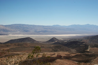
Once there I took a series of photos from the floor of the valley including to the eastern end of the valley where there is a patch of desert sand which has accumulated there by being blown along the valley floor to the end of the valley.
I stopped at the petrol station I had stopped at yesterday to get a drink and noticed glass Coca Cola bottles for sale. They looked slightly different to the other ones I had seen and on looking at them closely I saw that they were from Mexico. I bought a couple of them to get the bottle tops and also bought myself a chocolate bar for morning tea.

Driving back out of the valley I stopped at Father Crowley Point which provides a breath taking view back down into the valley floor and show off the colours of the mountain ranges in the area.
I then drove back out of the national park
Stopping at Bishop again on the way back home. I went into a coin shop and bought a old share certificate and a Guinness Book of Records in a paperback size. I when went to another two antique shops but only managed to pick up three small Australian Olympic badges featuring three different Koalas in Australian track suits.

I stopped at a supermarket and found a 12 pack of Heineken Light which I bought. I had not seen it before and will send it home in my last parcel I will post on Monday or Tuesday. I also picked up three M&M containers that have little plastic bladed fans on them that work by switching on a battery.

From there I went only 100 yards up the road to stop again at the Indian Casino I stopped at yesterday. I was after another pack of the playing cards that had been used on the gaming tables. The lady behind the counter said I could only get them if I joined the casino players club. I joined the club and got my members card and was given another packet of playing cards.

The members card had put on it $5 worth of poker machine credit on it so I went to the poker machines and put in the card expecting to have a couple of turns before the $5 ran out. Well I won with the first pull and again with the second. I ended up playing for about 10 minutes before I pulled $50 out of the machine. So I was glad I had stopped at the casino as the winning money will give me a tank full of petrol for the trip.

I then drove up to Tom's Place, which is a township consisting of a group of cabins, a lodge, a general store/café/bar building. Originally built in 1917 it has been a favourite place for fishermen and hikers ever since. The bar and Café are full of items that have been place there for 90 years. It is a great place for people to stop to look at the items on display.
Leaving there I travelled a bit further north to Mammoth Lakes which is a winter Skiing resort town but during the summer has some great lakes for fishing, water skiing and hundreds of miles of wilderness to walk the forest trails. There is a lot of pine and other large trees in the area.

Also in the town is the Mammoth Brewing Company and I stopped at their factory come shop to say g'day to the staff and get some memorabilia. When I said I had driven from Las Vegas to come to get some gear the lady said that it was the furthest she knew of anybody driving to come to them. Well she was blown away when I told her I had actually travelled around the world for 6 weeks to get to their brewery.

After talking for a while I bought a couple of T-shirts a cap, a glass and some coasters and the lady gave me some bottle tops, a couple of stickers, a couple of different plastic cup that had different events on them and two bottle labels.

I ten drove back to Lee Vinning and went through to a turn off to Bodie which is a ghost town last inhabited in 1932. In the 1890's it was the second largest town in California due to the gold rush boom. It has been preserved as a national park and still has over 200 building standing. Many of them still furnished as they were left after the bush fires destroyed most of the town in 1932. Unfortunately I was too late to go into the park area as it closes earlier during the afternoon once summer finishes at the end of August.
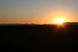
I then went to the shoreline of Mono Lakes and saw the formations called Tufa Towers. Tufa forms when fresh spring water full of calcium comes up through the bottom of the lake and mixes with the salty lake water full of carbonates. These two combine chemically to form calcium carbonate or Tufa. This material spreads out forming towers that tend to stop growing after rising above the lake level and get exposed to the fresh air.

I drove around the area for a while just looking at the mountain scenery.
From there I went back into town and visited the Laundromat to do my final load of washing before I head home on Tuesday. I did the washing and used the dryer before heading off to one of the two local restaurants to have a large steak and with fresh salad for dinner.

I then went back to the motel to get a reasonably early night as tomorrow I am off to Yosemite National Park and afterwards driving half way to San Francisco for tomorrow nights accommodation.